TRANSPORT, INDUSTRY AND TOWNS-ENGINEERING: OVERVIEW
- New towns born out of transport and their images: models, diagrams
The rise of seapower caused the development of harbour towns, and naval buildings, notably docks and dockyards; this meant a particular type of architecture and seashore layout - an area made of dry docks for the building and repair of ships, roperies and sail lofts for the equipment, and stores.
The development of buildings with a technical purpose, as well as ships, meant that new types of technical images were needed - scale models, measured diagrams: this was the beginning of 'information visualisation', and this is how we now derive information from historical documents on naval and industrial areas.
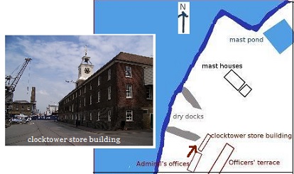
In present-day digital media, we use interactive tools to highlight the significant parts of such areas: on our webpage on Chatham Dockyards, we have a map and photos of the dockyards, with the option of making the points of view of the photos appear on the map by clicking on them - see screenshot below, showing the map with a brown arrow representing the direction of the photo towards the clocktower store building.

Study the chapter on Urban growth / Port cities (Harbours and dockyards - Chatham is part of the Dockyards section) on the Georgian Cities website, before doing the exercise on map and diagram design based on the page on Chatham.
- Transport and industry: issues and debates
* In the Georgian era, especially from the mid-18th century onwards, several types of industry developed - the coal and metal industry, the textile industry, the potteries ... - giving rise to new industrial areas especially in the Midlands and North of England, with towns such as Birmingham, Sheffield and Leeds, Manchester in the North West, the textile industries near Derby, the Potteries. Find out about them in the pages Urban Growth/Rising Industrial Centres.
* The rise of industry was dependent on
- technical inventions, such as the steam engine (see the pages on Birmingham on this)
- transport.
The exercises in this chapter and the next deal with the interaction of industry with both technological developments and transport.
When we study the economic and social history of trades and activities, we should raise the issue of their interaction.
- In what respects were the various industries interdependent?
- What reciprocity?
* how far were they facilitated by
- natural resources,
- geographical location,
- transport,
* and how far did they reciprocally induce new forms of transport? - how were the country and the city, landscapes and townscapes, interrelated?

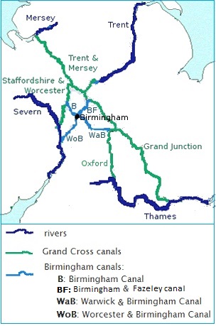
Above: a map showing the canal network which made Birmingham an inland port.
- External trade: in addition to inland transport, the question of sea or ocean navigation being an essential one for a maritime country like Britain, improvements in navigational techniques were necessary, in particular the scientific problem of finding one's position at sea; this led to the development of scientific institutions and thus new siginificant urban areas like the Royal Observatory at Greenwich.
----
To discuss these issues, read the chapters on industry and transport on the Georgian Cities website (Urban growth/Transport networks), and the page on Greenwich, together with the links from those pages.
- They raise the following issues, for which you will have questions to answer in the exercises:
* interaction between transport and economic activities
* chonology: which is the cause and which is the effect in technical evolution? what time lag between invention and practice?
* what are the conditions for technological transfer? is it dependent on geographical location, on the interaction between branches of industrial activity ? - They imply the following skills:
* answering different types of questions (matching questions, yes/no questions)
* graphic design - The topic of engineering will be based on two types of simulation or role-playing activities, to make you aware of technological history from the viewpoint of its own actors, as it was lived then.
To study the history of engineering in transport, your should be aware of the issues:
- the layout of the land - natural obstacles, hills and valleys, and the several ways to deal with them
- the distances, and the desirable/possible length of the journey
- the type of goods to be transported
- the existing design techniques in civil engineering
- the existing materials and tools.
Each of these problems is a choice for the engineer. To see alternative solutions, roll over the image.
Read the chapters on transport on the Georgian Cities website (Urban growth/Transport networks).
- the images created at the time of industrialisation in the Georgian era, new types of painting or miniature images on objects of daily life
- the digital simulations that we now produce:
§ the simulation of surveying tools used in the development of cities as shown in Georgian Cities, animations showing the use of a scientific instrument, the theodolite, in the pages on London/Maps and in the pages on Bath/Maps/A New and Correct Plan/The Royal Crescent/Construction, and the calculation problem 'The engineer's problem' on the North Bridge of Edinburgh (Edinburgh/Maps/Artists'viewpoints/North Bridge).
§ the digital 3D modelling of Georgian engines, the present day versions of earlier small engineering models in metal; this is a screenshot of a model of Watt's steam engine, showing the piston activated by the boiler and in turn activating the wheel; the model itself has its piston moving and the wheel turning, if you wish to see it in action, you should instal the open software Blender and open the model 'The steam engine' enclosed in the current Topic. To study the historical context in Georgian Cities, read the page on Birmingham , with the link on 'steam engine'.
You will be asked to reflect on what such simulation activities teach us about the technology of the past and its role in urban history.