CANALS
https://www.nationalgeographic.org/photo/early-transportation/
https://transportgeography.org/contents/chapter1/emergence-of-mechanized-transportation-systems/american-canals-19th-century/
(L)
A clear history of the first canals in the US.
Very good maps on Wikipedia by googling just " canals in the US".
http://xroads.virginia.edu/~Hyper/DETOC/transport/canal.html
....................................................
Very precise and detailed: I did not know Canals were so important for the development of the West.
We imagine horses, wagons...but the real growth and movements of people and goods West, started with the Canals.
( Dewitt Clinton: named Clinton's ditch by his opponents! 1817-1825 350 miles).
https://www.ushistory.org/us/25a.asp
.....................................................
One of the best:
List of all canals: very clear disposition in an array.
"The golden age of historic transportation canals was from 1820 until railroads began to replace canals in the 1850s."
https://www.familysearch.org/wiki/en/US_Migration_Canals
......................................................
Very good pictures for a present exploration.
https://www.nps.gov/subjects/transportation/canals.htm
..........................................................
Et encore mieux: tonnes d'infos.
Vais essayer te faire un pré- tri, mais il faudrait que tu le lises.
Il faut aller à chaque fois à des sites différents :
https://americancanalsociety.org/
..............................................................
........................................................................... |
Pictures and present day boating.
In the recent years as commercial traffic has turned towards truck, rail and ships, but the canal has reinvented itself as a destination for the recreational boater. The Canal Cooperation has spent hundreds of millions of dollars on reviving the canal-side towns that once were prosperous from passing commercial barges, they are opening up their town docks and walls to recreational boaters, with many providing free docking, and a good percentage with power, water and other services. This effort has made the canal a world class destination for a short weekend getaway or an entire vacation.
Lois McClure at the 2007 Waterford Tugboat Roundup.
Rich History: A State Built by Canals
The Erie Canal is often the first canal that comes to mind when one thinks of the canals across New York, but it is only one of the more than thirty navigable canals that were built across New York in the past 280 years. The first canal, dug on the Mohawk River near Utica, dates back to 1730 ([1]), 95 years before the Erie Canal and 58 years before New York joined the Union!
The Little Falls Canal, opened in 1795, was the first major canal and started the groundwork for the Rome Canal and eventually the Erie Canal. Following the lead of the major success of the Erie Canal, residents from across the state petitioned the state to build a canal in their neck of the woods. Nearly all of today's major cities and villages across the state once had a canal through it which would connect to the Erie Canal and the world, or was directly
http://www.nycanals.com/Main_Page ........................................................................... |
Impact of the railways: to be read.
I put just part of it.
https://www.britannica.com/technology/canal-waterway/United-States
Login
ArticleMediaAdditional Info
LOAD PREVIOUS PAGE
United States
In the United States, canal building began slowly; only 100 miles of canals had been built at the beginning of the 19th century; but before the end of the century more than 4,000 miles were open to navigation. With wagon haulage difficult, slow, and costly for bulk commodities, water transport was the key to the opening up of the interior, but the way was barred by the Allegheny Mountains. To overcome this obstacle, it was necessary to go north by sea via the St. Lawrence River and the Great Lakes or south to the Gulf of Mexico and the Mississippi. A third possibility was the linking of the Great Lakes with the Hudson via the Mohawk Valley. The Erie Canal, 363 miles long with 82 locks from Albany on the Hudson to Buffalo on Lake Erie, was built by the state of New York from 1817 to 1825. Highly successful from the start, it opened up the Midwestern prairies, the produce of which could flow eastward to New York, with manufactured goods making the return journey westward, giving New York predominance over other Atlantic seaboard ports. The Champlain Canal was opened in 1823; but not until 1843, with the completion of the Chambly Canal, was access to the St. Lawrence made possible via the Richelieu River. Meanwhile, Canada had constructed the Welland Canal linking Lakes Ontario and Erie. Opened in 1829, it overcame the 327-foot difference in elevation with 40 locks, making navigation possible to Lake Michigan and Chicago. Later the St. Mary’s Falls Canal connected Lake Huron and Lake Superior. To provide a southern route around the Allegheny Mountains, the Susquehanna and Ohio rivers were linked in 1834 by a 394-mile canal between Philadelphia and Pittsburgh. A unique feature of this route was the combination of water and rail transport with a 37-mile portage by rail by five inclined planes rising 1,399 feet to the summit station 2,334 feet above sea level and then falling 1,150 feet to Johnstown on the far side of the mountains, where a 105-mile canal with 68 locks ran to Pittsburgh. By 1856 a series of canals linked this canal system to the Erie Canal. vIraq: Irrigation and canals
Many dams are needed on the rivers and their tributaries to control flooding and permit irrigation. Iraq...
Meanwhile, the Louisiana Purchase of 1803 had given the United States control of the Mississippi River, and it became the main waterway for the movement of Midwestern produce via New Orleans and the Gulf of Mexico. Developments included the Illinois-Michigan Canal, connecting the two great water systems of the continent, the Great Lakes and the Mississippi. Entering Lake Michigan at Chicago, then a mere village, the canal triggered the city’s explosive growth. Several canals were constructed subsequently to link up with the Erie and Welland canals and the St. Lawrence, and a comprehensive network of inland waterways was established.
Impact of the railways
With the development of rail transport in the 19th century, canals declined as the dominant carriers of freight, particularly in the United States and Britain. In continental Europe the impact was less marked, because the great natural rivers already linked by artificial waterways constituted an international network providing transport economically without transshipment; the terrain was more favourable and the canals larger and less obstructed by locks. Elsewhere canals could not compete with rail. They were limited both in the volume carried per unit and in speed; they were too small, too slow, and fragmented; and the railways, as they became integrated into national systems, provided a far more extensive service with greater flexibility. The canals were further handicapped because they were not, for the most part, common carriers themselves but were largely dependent on intermediate carrying companies. Although transport on the canals was for some time cheaper than rail, the railways gradually overcame this advantage. To modernize and extend the waterways to enable larger boats to ply them, to reduce the number of locks that slowed down movement, and to provide a more comprehensive service all required capital investment on a scale that made the return problematic. The railways exploited the difficulties of the canals by drastic rate cutting that forced many canal companies to sell out to them. In Britain a third of the canals had become railway-owned in the 1840s and ’50s, and many were subsequently closed down. In the United States, half the canals were abandoned. The railways thus succeeded in eliminating their competition and obtained a near monopoly of transport, which they held until the arrival of the motor age.
Three great canals
The Kiel Canal
The 19th century saw the construction of the Kiel and Suez canals. The former carries tonnage many times that of most other canals. Frequent attempts had been made to make a route from the Baltic to the North Sea and thus to bypass the Kattegat and the dangerous Skagerrak. The Vikings had portaged ships on rollers across the 10-mile Kiel watershed, but not until 1784 was the Eider Canal constructed between the Gulf of Kiel and the Eider Lakes. A little more than 100 years later, to accommodate the largest ships, including those of the new German navy, the Kiel Canal was widened, deepened, and straightened, cutting the distance from the English Channel to the Baltic by several hundred miles. Running 59 miles from locks at Brunsbüttel on the North Sea to the Holtenau locks on the Gulf of Kiel, the canal crosses easy country but has one unique engineering feature. At Rendsburg, to give clearance to the largest ships, the railway was made to spiral over the city on an ascending viaduct that crosses over itself before running on to the main span above the water. |
TRAINS
pr les transports aux USA, Vanderbilt (trains) avait, je crois, une fortune égale au budget des USA
Le Transcontinental, la Guerre civile
pages sur Smithsonian :
https://www.si.edu/object/moment-lincoln-realized-military-power-railroads:yt_Kv9efDIUBVQ
https://postalmuseum.si.edu/the-transcontinental-railroad-turns-150
https://www.si.edu/spotlight/trains
encore la Guerre
civile :
https://www.american-rails.com/civil.html
"There were many reasons for the South's
failure to achieve victory. One of the most noteworthy was its inability
to properly utilize the railroad. " détaillé ds l'article
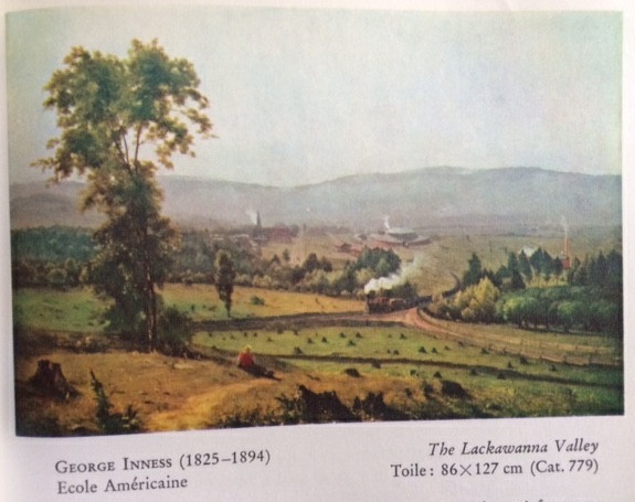
La légende des trains américains représentés en
peinture et au cinéma :
En peinture
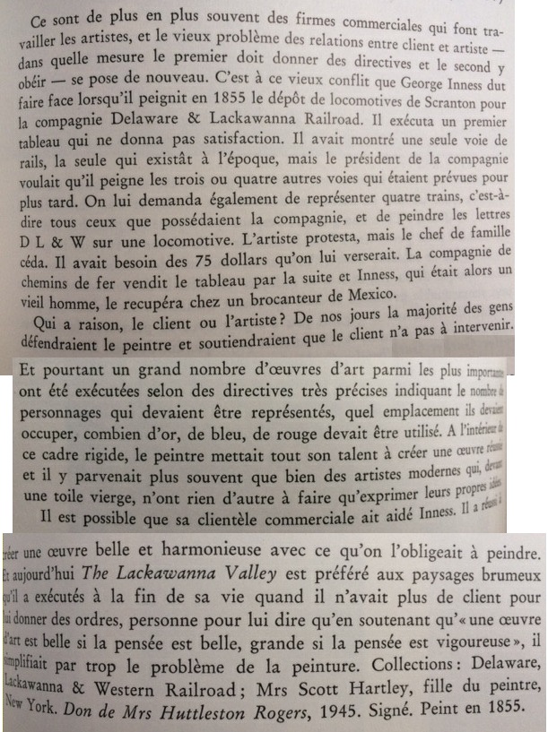
Dès le milieu du XIX e s, les compagnies ferroviaires
faisaient diffuser leur image par des artistes avec des tableaux de paysage
traversé par le train - avec pbs pcq par exemple le propriétaire exigeait du
peintre qu’il calligraphie le nom de la compagnie visible sur le côté du train
au lieu de faire un flou artistique ! Ci-joint une reproduction et le commentaire
tiré d’un livre sur la National Gallery of Washington que j’avais ds mon
adolescence, cadeau de Noël ou autre. John Walker, Trésors de la peinture à la National Gallery, Washington. Paris:
Somogy, 1964.


une ville qui est justement sur ce circuit de Lackawamma
Valley a un musée de vieux trains https://www.nps.gov/stea/index.htm
voir https://www.american-rails.com/dlw.html
Au cinéma :
je me suis souvenue d'avoir vu ds mon enfance L'Infernale Poursuite (1956)
https://www.allocine.fr/film/fichefilm_gen_cfilm=49753.html
train pendant la Guerre de Sécession- Guerre civile (nordistes qui
s’emparent d’une locomotive sudiste et font circuit sur elle pour détruire les
installations)
Mettez ds google The Great
Locomotive Chase

