Georeferencing (field trip, using applications for mobile devices, or at-desk)
Conditions d’achèvement
![]() If you need definitions of the different types of exercises or activities to be submitted on moodle, look at the User's Guide..
If you need definitions of the different types of exercises or activities to be submitted on moodle, look at the User's Guide..
The text below is a 'read-only' question; it is meant to give visitors an idea of possible exercises. Registered students should click on the 'Submission' button available to them in order to move to the exercise page and write or attach their contribution.

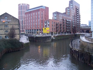
Leeds, the junction of the Leeds and Liverpool canal (left) and the Aire (right)
- Preparation: In Leeds,
*trace the place represented in the photo and position yourself at the standpoint
*with a map/georeferencing application on your mobile device, zoom on the place. - Exercise: using maps at two different scales (i.e. close-up and regional map, or plan of the city and map at the national scale), explain the technical and economic significance of this geographical positioning.
Skills:
- linking on-location views and maps
- using georeferencing applications
- raising issues in economic geography
Note: a converse exercise ('geotagging' - following page) concerns Bristol - taking photos instead of starting from existing photos, positioning them using the internal application of the device instead of comparing them with an external map.