Maps and points of view in Edinburgh (field trip exercise using mobile devices, or PC)
![]() If you need definitions of the different types of exercises or activities to be submitted on moodle, look at the User's Guide.
If you need definitions of the different types of exercises or activities to be submitted on moodle, look at the User's Guide.
The text below is a 'read-only' question; it is meant to give visitors an idea of possible exercises. Registered students should use the other version of the course "Georgian Cities: S2".
Exercise based on the pages of the Georgian Cities website on the New Town of Edinburgh
- The exercise may be used in a field trip, visiting Charlotte Square and using a mobile device such as a tablet to draw the required diagram. It may also be used in an at-desk simulation of a field trip, searching the web (Georgian Cities and other websites) for photos of the views the student might have in Charlotte Square.
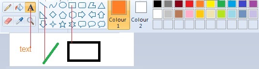
- It involves practice of any basic digital image program, such as Paint; any program standardly available on all computers will be sufficient. Those who are familiar with professional drawing tools may use them, but this is not necessary. See below the elementary tools.
In Edinburgh:
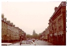
With a simple paint programme, draw a diagram of the relative positions of George Street, Charlotte Square, St George's Church, as viewed from the intersection of George Street and Castle Street; indicate the viewer's standpoint and axis of the view - you may use a georeferencing application or geotagging application (as described in Unit 11).
Write a text to give the key to the icons and colour coding used in your diagram; explain your procedure and the points you wish to emphasise.
Skills:
- identifying lines of sight in neoclassical town design using online resources - a comparison of engravings, photographs, interactive maps
- use of simple drawing and paint programmes
- use of legends and icons ('colour coding': using different colours to represent separate types of items, i.e. types of buildings, on a map).
Reference: pages on cityscapes and points of view in city spaces.
Drawing tools you will need in your image program: how to write a text - how to draw a line - how to draw a rectangle. After opening the program, select the colour you wish in the colour palette by clicking on it, select the tool in the tool palette - A to write, the line to draw a line, and the rectangle to draw the corresponding shape - , and use it to draw in the white space; then move to the next tool you need.